|
|
- Your Online Truckstop for semi truck drivers since 1999 |
Toll-Free |
|
|
- Your Online Truckstop for semi truck drivers since 1999 |
Toll-Free |
|
{Click the DieselBoss Logo at the top-left of this page to return to the main Home Page at any time} |
|
|
Big truck laptop
computer stands, desks, and computer mounts for semi's, pickup trucks, and
RV's are always here. As an authorized Ram Mount dealer, we provide
the most rugged and functional laptop computer mounts and accessories for truckers,
RV, and
non-truckers alike.  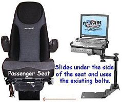 Vu Qube satellite TV antenna for big-trucks 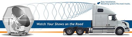 Easy install, easy signal acquisition, weatherproof. Works with DirectTV, Dish Network, Bell ExpressVu, or Free-to-Air! |
Latest
site news:
Truck
GPS - Rand McNally TND, PC*Miler Navigator, and CoPilot Laptop
Don't live with future regrets -
Do it right the FIRST TIME |
|
Check out SaluteHeros.org and AnySoldier.com to help support our troops Site best viewed at 1024X768 or higher and High Color. Some areas require Java enabled. Legal Stuff | Last Updated: June 4, 2012 | Site Map |
Copyright© 1999 - 2011 DieselBoss®, Inc. All Rights
reserved worldwide
Click here if you are
interested in advertising in this or other DieselBoss® pages.